Smarter forestry starts with better data

Get more visibility, more control, and more productivity from your forestry operation with John Deere precision forestry. TimberManagerâ„¢ and Timbermaticâ„¢ Maps form the foundation of precision forestry. Precision Forestry helps optimise your machines, your uptime, and your jobsites, ultimately leading to improved productivity. RDO Equipment employs a team of technology specialists trained to help you realise the benefits of Precision Forestry with as much or as little involvement as you desire.

And to help keep your equipment running in peak condition, John Deere Connected Supportâ„¢ creates a partnership between us and teams at the factory to improve the uptime and profitability of your equipment. The John Deere Operations Centerâ„¢ lets you monitor your fleet for any machine issues and is ready to provide proven solutions to minimise downtime.

ENQUIRE NOWFIND NEAREST BRANCH

Manage the back office.

TimberManagerâ„¢

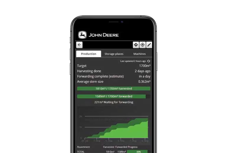
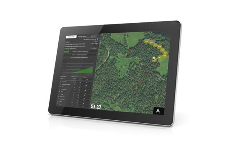
TimberManager is a web-based solution for PCs, tablets, and mobile phones, allowing you to follow your progress on the jobsite. Combined with TimberMatic™ Maps, this software provides complete visibility of your operation — from land harvested to the machines at work — so you can streamline communication and increase efficiency.

The contractor has real-time information about the progress and an estimate of the completion of the work. It is easy to keep direct contact to the work site through the message board.

With TimberManager™, the business’s efficiency increase through reduction of unnecessary tasks.

Manage your work in the woods.

Timbermaticâ„¢ Maps

TimberMatic Maps is an innovative onboard software solution that helps you visualise your jobsites in new ways. With real-time production views, optimised routes, and shared wireless connections between machines, it’s never been easier to take your forestry operations to the next level.

Model compatibility

TimberMaticâ„¢ Maps and TimberManagerâ„¢ are available across most John Deere forestry equipment models, including skidders, wheeled and tracked harvesters, tracked feller bunchers, forwarders, and swing machines. The system can also be retrofitted to many existing machines, making it easy to upgrade your current fleet.

ENQUIRE NOWFIND NEAREST BRANCH

Unlocking value through precision forestry

Real-time updates

TimberMatic Maps is an advanced way of seeing the jobsite. Live production and location data is shared among John Deere forestry machines via a wireless mobile network and real-time cloud connection. Operators can view all machine locations and the current logging situation in real time using the TimberMatic Maps display through the TimberMatic control system in the machine cab.

Precise progress tracking

As the job progresses, production data and logging routes are updated in real time on TimberMatic Maps, displaying the actual, up-to-theminute status of the jobsite. Using the Areas of Interest and Points of Interest functions, operators and contractors can easily mark hazards, obstacles, soft ground, and challenging terrain, in the cab or on a tablet. These are shared in real time with all crew members, optimizing jobsite awareness and productivity

Fleet optimisation

Go beyond machine-level management with information and insights to improve efficiency and precision.

Simplified mapping

TimberMatic Maps accommodates allcommon map formats, from simplehand-drawn maps to elaborate shape-files or pdfs. Standard satellite ortopographic imagery can be sent directlyto machine through onboard cellular connection. Using TimberManager,owners can change map features and share updates via an online, cloud-basedsolution without having to physically visit each machine.

Remote monitoring

In addition to TimberMatic Maps onboard the machine, contractors and supervisors can monitor live progress from anywhere at any time using TimberManager — a web-based solution for PCs, tablets, and mobile phones. Select a logging site and view harvesting, skidding, and forwarding progress at a glance, along with more detailed information including machine production and efficiencies.

Live production view

TimberMatic Maps shows the precise GPS-based location, estimated volume, and up to two species of timber when manually counting stems with a feller buncher — for simple, efficient planning. Forwarder operators can immediately see where certain species are located and choose the optimal route to pick up and transport a full load of a desired assortment to the landing.

Enquire about Precision Forestry today

Learn more about Precision Forestry by visiting your local RDO Equipment branch in person, by phone, or request a quote online.

"*" indicates required fields

This field is for validation purposes and should be left unchanged.

Malcare WordPress Security